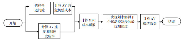
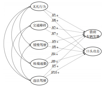
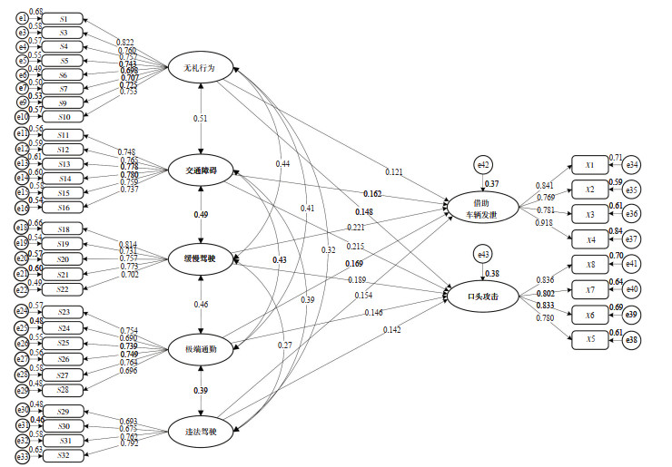
Current Issue

2024, Volume 42,  Issue 1

Display Method:
2024, 42(1): .
Abstract(51) HTML (33) PDF(10)
Abstract:
A Review of Studies on Large-scale Aircraft Scheduling Problems
ZHANG Baocheng, RAN Bowen
2024, 42(1): 1-10. doi: 10.3963/j.jssn.1674-4861.2024.01.001
Abstract(104) HTML (48) PDF(25)
Abstract:
Aircraft scheduling is a key link in flight planning, directly affecting the safety and economic efficiency of civil aviation transport. With the expansion of the aircraft fleet in China, research on large-scale aircraft scheduling problems (ASP) has become urgent. However, the fleet assignment model and aircraft scheduling models (ASMs) with different decision-making objectives (e.g., operational profitability, maintenance requirements, and robustness) cannot meet the needs since the number of constraints and the scale of the problem are often limited. By analyzing the connections and limitations of the existing ASMs, this paper summarizes the model and its solution algorithms for large-scale integrated ASP, analyzes the scope of application, advantages and disadvantages of each algorithm, and finds that: the phased scheduling model cannot guarantee the global optimal solution, while the integrated aircraft scheduling model is more practical; the exact algorithm can theoretically guarantee the optimal solution, but it is complicated, time-consuming, and difficult to decompose; the heuristic algorithm is fast and simple, but quality of the solution and the stability of the algorithm cannot guaranteed. Lastly, further research directions for large-scale integrated ASP are concluded: ① In terms of problem modelling, an integrated scheduling model can be established to optimize the route network structure and overcome the limitations of the existing models by taking into account factors such as route demand, time-balanced scheduling, and personalized crew assignments; ② In terms of problem-solving, Benders decomposition and column generation algorithms can be combined to decompose the whole problem into relatively simple main problems and sub-problems, reducing the difficulty of solving; additionally, the exact algorithms and heuristic algorithms can be combined to reduce the computational time and guarantee the accuracy of the solution, improving the solution efficiency.
Comprehensive Study on Route Flight Separation and Control Frequency of Urban UAV
ZHANG Jian, WANG Shouyuan, ZHAO Yifei, LU Fei
2024, 42(1): 11-18. doi: 10.3963/j.jssn.1674-4861.2024.01.002
Abstract(61) HTML (28) PDF(15)
Abstract:
Focusing on urban UAVs route flight, in order to ensure the safety of operation, it is necessary to equip the UAVs with appropriate separation. For the longitudinal flight scenario of the same route, a separation regulation model that considers the conflict frequency and collision probability and complies with the ICAO separation principle is investigated. By considering only the collision risk of UAVs positioning error, the longitudinal separation is obtained, which is used as the benchmark for the subsequent separation calculation. By considering the position uncertainty caused by both positioning error and velocity error, the collision risk along with the flight progress of UAVs is calculated. Increasing the longitudinal separation will delay the time to break through the target level of safety, but as the flight progresses, the collision risk will eventually overstep the target level of safety. Based on this finding, the method of UAV position regulation mechanism is proposed, and the distance between two aircraft is calibrated periodically. For a given target level of safety, a curve of longitudinal separation and position control frequency can be obtained, and a game relationship is found to exist between them. Implementation of high-frequency control, a smaller route separation is needed. Otherwise, the required route separation should be increased. In order to take into account, the double constraints of urban airspace and position control ability, a compromise scheme to select the separation and the control frequency at the maximum curvature is presented. It is found that the more stringent the safety target level requirements, the greater the required frequency of regulation and flight separation. The experimental analysis finds that when the target level of safety is 5×10⁻⁹ times/flight hour, the required control frequency is 87 times/hour and the required longitudinal separation is 90 m. At the same time, in the actual operating environment, the application of the above evaluation models and methods can objectively select the required separation and regulation frequency. The research in this paper can consider the safety of urban logistics UAV air operation and improve urban airspace utilization and delivery efficiency.
A Safety Evaluation of Vertical Separation for Multi-rotor eVTOL Based on an Improved Event Model
WANG Xinglong, WANG Youjie
2024, 42(1): 19-27. doi: 10.3963/j.jssn.1674-4861.2024.01.003
Abstract(48) HTML (37) PDF(5)
Abstract:
The multi-rotor electric vertical take-off and landing vehicle (eVTOL) is a future vehicle, that has been a research hotspot in recent years. However, the limited accuracy of vertical positioning and potential dangers of crossing flight hamper the establishment of the operational separation standard (OSS) for eVTOL, which makes it far from the application in practice. To explore the OSS for eVTOL, the shape of the eVTOL is considered, which is wider at the bottom and taper at the top, an improved Event-based vertical collision model is developed, and the safety evaluation method for eVTOL is proposed based on the improved model. The proposed method considers the main characteristics of eVTOL such as the shape, navigation accuracy, operation feature, positioning error, flight speed, speed error, etc., uses a conical frustum collision box instead of the cuboid box in the original model, and introduces relative speed, probability of lateral overlap and probability of vertical overlap as the parameters in safety evaluation method, capturing the characteristics of the eVTOL, reducing the computational redundancy, and enhancing the accuracy of the collision model. To demonstrate the proposed model and method, the multi-rotor eVTOL EHang 216-S is taken as an example, and the vertical separation minimum (VSM) under different target levels of safety (TLS) and navigation accuracy are calculated. The results show that: ① the reduction of the TLS and the navigation accuracy will lead to the reduction of the VSM. ② When the TLS is set as 1×10⁻⁶ times/flight hour and the navigation accuracy is set as required navigation performance of 10 (RNP10), VSM can be reduced to 11 meters. ③ When the navigation accuracy is RNP10 and the VSM is 11 meters, the calculated collision risk by the proposed method will be lower than the original method by 24.78%. It indicates that the introduction of the conical frustum collision box in the safety evaluation for eVTOL would result in a more accurate and reasonable calculation of collision risk than the original method, providing theoretical support for the establishment of vertical separation standards for eVTOL.
Drivers' Mental Load Characteristics at the Entrance and Exit of High-density Interchanges Based on Heart Rate Variability
MU Junlong, YANG Di, JIAO Chengwu, KONG Fanxing, CHEN Zhenghuan, XU Jin
2024, 42(1): 28-40. doi: 10.3963/j.jssn.1674-4861.2024.01.004
Abstract(59) HTML (36) PDF(15)
Abstract:
Interchange bridges serve as important nodes in road traffic networks, facilitating the redirection of traffic flows in different directions. Currently, high-density interchanges are increasingly common in urban road networks. With closer spacing of high-density interchanges compared to regular ones, denser vehicle weaving occurs and drivers are required to perform merging and diverging maneuvers in a shorter time. To investigate the impact of interchange spacing on drivers' mental load and the corresponding statistical characteristics in the entrances and exits of high-density interchanges, a segment of the Inner Ring Expressway in Chongqing with four consecutive interchanges, three of which are high-density interchanges, was selected as the research site. Electrocardiogram data from 47 drivers during on-road experiments were collected using in-vehicle instruments. Differential analysis was conducted on the temporal and spectral indices of driver heart rate variability between the entrances and exits of high-density and regular-spacing interchanges, revealing the distributions of drivers' mental load in these sections. The results indicate that: There is no significant difference in the temporal index of heart rate variability between drivers passing through the entrances and exits of regular-spacing and high-density interchanges. However, there is a significant difference in the spectral index, i.e., the ratio of low-frequency to high-frequency power of heart rate variability (LF/HF), which is believed can serve as the main indicator for evaluating drivers' mental load in interchange entrances and exits. When passing through the entrances of high-density interchanges, the LF/HF significantly increased compared to the one when passing through the entrances of regular-spacing interchanges, indicating that insufficient interchange spacing would increase mental load in the entrances of interchanges. Conversely, the LF/HF is significantly higher when passing through the exits of regular-spacing interchanges than the one when passing through the exits of high-density interchanges, indicating greater mental load when passing through exits of regular-spacing interchanges. For high-density interchanges, drivers' mental load in entrances are slightly higher than that in exits.
Influences of Wheel Rail Friction Coefficient on the Dynamic Response and Wheel Wear of Low Floor Light Rail
LI Xue, WANG Yuexin, WANG Kaiyun
2024, 42(1): 41-48. doi: 10.3963/j.jssn.1674-4861.2024.01.005
Abstract(46) HTML (31) PDF(2)
Abstract:
Taking a certain light rail line as the basis, a low-floor trams vehicle-track coupled dynamic model is established utilizing the multi-body dynamics software Universal Mechanism (UM). LM wear-type treads and R50 standard rails are selected, and the US VI irregularity track spectrum is used as the line excitation. Firstly, the vehicle's dynamic response and wheel wear is studied under five different friction coefficients, based on Hertz and simplified Kalker theories, as well as the Archard model. Then, the variation patterns of safety indicators under 96 groups of wheel wear profiles, corresponding to four different running mileage stages, are further analyzed. Finally the changes of the safety indicators of the vehicle passing through curves under different wheel wear profiles at four different mileage stages with the friction coefficient are studied. The results show that the derailment coefficient, lateral wheelset force, lateral wheel-rail force and lateral car-body acceleration are significantly influenced by the friction coefficient, whereas the wheel load reduction rate and vertical car-body acceleration are not sensitive to changes in the friction coefficient. The depth of wheel wear increases with mileage and friction coefficient, and the wear situation of independently rotating wheels is more severe under the same working conditions. After the vehicle has traveled 40 000 km, the lateral wheel-rail force, lateral wheelset force and derailment coefficient generally exhibit an increasing trend with mileage, while the wheel load reduction rate remains unaffected. Under the combined effects of different friction coefficients and operating mileages, the positions of peak values of the lateral wheel-rail force, lateral wheelset force and derailment coefficient occur at different locations, while the wheel load reduction rate remains relatively stable.
Impacts of Traffic Safety Awareness on Risky Riding Behaviors among Non-Motorized Cyclists
PEI Yulong, LONG Yu, MA Dan
2024, 42(1): 49-58. doi: 10.3963/j.jssn.1674-4861.2024.01.006
Abstract(75) HTML (28) PDF(25)
Abstract:
Traffic safety awareness (TSA) of cyclists plays a crucial role in promoting safe behavior, but it is difficult to directly measure due to its multidimensionality and complexity. To investigate the impact of TSA on risky riding behavior (RRB), safety attitude, risk cognition, safety quality, and external environment are selected as the structural elements (or TSA elements) by using the cloud model, and the empirical research is carried out based on questionnaire data. The"TSA-RRB"structural equation model is developed, and the causal pathway from each TSA element to RRB is quantified by Mplus 8.0. The Bootstrap method is applied to verify the mediating roles of safety quality, risk cognition, and safety attitude, and the direct and indirect relationships between the external environment and RRB are sorted; subsequently, a hierarchical regression model is employed to validate the moderating effect of traffic safety knowledge (TSK) between TSA and RRB. The findings of this research are concluded as follows. ① the proposed structural equation model fits well with questionnaire data, and four TSA elements all have significant negative correlations with RRB. Specifically, risk cognition has the most considerable impact on unintentional behavior (-0.331), while safety attitude displays the greatest influence on intentional behavior (-0.332). ② Mediating effects show that the external environment, as an exogenous variable, could either directly act on riding behavior or indirectly affect the behavior through other TSA elements such as safety quality, risk cognition, and safety attitude. ③ The moderation effect of TSK is significant (∆R2 = 0.017, P < 0.05), enhancing the negative correlations between TSA and RRB, and the simple slope relationship between TSA and RRB implies that the effect of TSA on RRB is strengthened when the level of TSK is high.
Factors Affecting Red-light Running Behaviors of Takeaway Delivery Riders Considering Heterogeneity in the Means and Variances
CAI Lingxiao, ZHOU Bei, ZHANG Shengrui, MA Huizhong, ZHANG Xinfen, LU Xi
2024, 42(1): 59-66. doi: 10.3963/j.jssn.1674-4861.2024.01.007
Abstract(54) HTML (29) PDF(16)
Abstract:
To address the frequent occurrences of takeaway delivery riders running red-light and the high risk of crashes associated with this behavior, a filed survey is conducted at multiple signalized intersections in Xi'an, the red-light running (RLR) behaviors of delivery riders are investigated. The RLR behavior is taken as the dependent variable, while independent variables included rider personal characteristics, crossing behavior characteristics, and traffic and environmental features. A random parameter Logit model considering heterogeneity in the means and variances was constructed. Parameter estimation was carried out using Halton sequence sampling, and the impact of each independent variable on the dependent variable was quantitatively analyzed through the estimation results and average marginal effects. The findings indicate that Eleme and UU delivery riders have a lower probability of RLR. Variables such as arriving during the second or third phase of the red light, waiting behind the stop line for the green light, and higher conflicting direction traffic volumes significantly reduce the probability of RLR. Conversely, an increase in the number of violators in the same direction, the noon peak hours and evening peak hours significantly increase the probability of RLR. Among these, the variable that most significantly increases the probability of RLR is the evening peak hour, with an average marginal effect of 0.278; the variable that most significantly decreases the probability of RLR is waiting behind the stop line, with an average marginal effect of -0.222. Besides, the parameters of waiting behind the stop line and evening peak hours are random parameter variables, following a normal distribution with means and standard deviations of -1.379, 1.359 and 2.502, 5.360, respectively. Besides, both random parameters exhibit significant heterogeneity in means and variances. For the variable of waiting behind the stop line, arriving during the second phase of the red light increases both the mean and variance of this variable's parameter, hence increasing the probability of RLR and the randomness of its impact on this behavior. For the evening peak hour, a higher volume of motor vehicle traffic reduces both its parameter's mean and variance, thus lowering the probability of RLR and reducing the randomness of its impact on this behavior. Additionally, having only one violator also reduces the variance of the evening peak hour's parameter.
A Method for Indoor Passenger Identity Recognition on Large Cruise Ships Based on Vision and Inertial Sensors
FENG Xiaoyi, MA Yuting, CHEN Cong, WANG Yifei, LIU Kezhong, CHEN Mozi
2024, 42(1): 67-75. doi: 10.3963/j.jssn.1674-4861.2024.01.008
Abstract(40) HTML (18) PDF(6)
Abstract:
The internal structure and scenes on cruise ships are complex and the surveillance camera offers limited depth information, which makes it difficult to identify the location, heading, changes in heading, and the identity of the passengers by the traditional passenger identity recognition method (PIRM) based on a single surveillance camera. To fill the gap, a novel method for indoor PIRM based on vision and inertial sensors is proposed. The YOLOv5 algorithm is used to extract the bounding box of each passenger and assign the pixel coordinate for each box; the pixel coordinate is further converted into the world coordinate system fixing on the camera according to the 2D-3D coordinate transformation formula; an improved neural network model then is used to estimate the true heading angle of passengers in the camera coordinate system. The inertial sensor data from passengers' smartphones are collected to detect the acceleration of the passengers and their walking states; the true heading angle of passengers in the world geodetic system is calculated by integrating magnetic field intensity; then, the extracted visual and inertial sensor data are fused, and limited features of passengers and their relationships are encoded, including walking state, step length, relative heading angle, relative distance, so as to solve the error accumulation problem of sensor signals. A similarity calculation formula between the features is proposed based on the two multi-correlation graphs, and the Vision and Inertial Sensors Graph Matching (VIGM) algorithm is employed to solve the maximum similarity matrix, which could identify the same passenger in both graphs. Lastly, to validate the proposed method, four scenes on the"Yangtze River Golden 3"cruise ship are employed (including the lobby, chess room, multi-function hall, and corridor), and it is found that: the average matching accuracy (AMA) of the proposed VIGM algorithm reaches 83.9% with the 1—3 s time window; the AMA of the proposed algorithm is only 4.5% lower than the ViTag algorithm using high-cost depth cameras. The results of experiments show that the proposed PIRM and VIGM algorithm have low implementation costs but equivalent performance compared to the method using high-cost depth cameras on large cruise ships.
Joint Optimization of Intersection Signal Control and Trajectory Control in Novel Heterogenous Traffic Flow Scenarios
WANG Fangkai, YANG Xiaoguang, JIANG Zehao, LIU Congjian
2024, 42(1): 76-83. doi: 10.3963/j.jssn.1674-4861.2024.01.009
Abstract(49) HTML (15) PDF(17)
Abstract:
In scenarios of mixed traffic flows consisting of human-driven vehicles (HDVs) and connected and autonomous vehicles (CAVs), existing intersection joint optimization methods place high computational demands on either centralized controllers or on-board computing units due to centralized and individual vehicle controls, respectively. This paper studies a joint optimization method that integrates the cell transmission model (CTM) with a bi-level programming model. This approach utilizes adjustable cell lengths to balance the computational requirements needed for signal control and CAV trajectory optimization, thereby flexibly allocating computational resources based on the capacities of central controllers and on-board computing units. The upper-level model predicts traffic flow states and optimizes signal control parameters by dynamically adjusting cell lengths to reduce the computational load on central controllers. The lower-level model uses these traffic state predictions to globally plan CAV trajectories, thereby enhancing intersection throughput. To improve solution optimality and real-time response, an iterative optimization algorithm that combines stochastic gradient descent with a genetic algorithm is employed to avoid local optima and enhance solution efficiency. Using data from the intersection of Xian-feng Middle Road and Chun-feng South Road in Wuxi City as an example, the optimization effects under different CAV penetration rates were verified. Results show: ① Compared to the baseline scenario, the proposed collaborative optimization scheme can reduce average vehicle travel time at the intersection by up to 8.09%, effectively reducing congestion propagation upstream. ② With CAV penetration rates of 30%, 60% and 90%, the optimization percentages are 2.51%, 5.08% and 7.88% respectively. ③ In scenarios where the inbound flow rate exceeds 3, 000 pcu/h, optimal signal control schemes can still be obtained within 100 seconds, supporting real-time optimization. The method can effectively improve urban traffic congestion and enhance the efficiency of intersections in novel mixed traffic flow scenarios.
A Multi-objective Traffic Control Method for Connected and Automated Vehicle at Signalized Intersection Based on Reinforcement Learning
JIANG Han, ZHANG Jian, ZHANG Haiyan, HAO wei, MA changxi
2024, 42(1): 84-93. doi: 10.3963/j.jssn.1674-4861.2024.01.010
Abstract(38) HTML (19) PDF(9)
Abstract:
To address the issue of high energy consumption and low efficiency of connected and autonomous vehicles (CAV) in dynamic traffic environments under traditional control methods, a reinforcement learning-based control approach for CAV is proposed, aiming at reducing energy consumption, improving travel efficiency, and enhancing driving comfort. By considering the interactions between CAV and traffic signal control systems, as well as physical environmental factors, we collect signal phase and timing (SPaT), preceding vehicle speed and position, and other information to establish the state space of the reinforcement learning framework. Furthermore, an energy consumption model is established with the limit of battery energy recovery, and a multi-objective weighted reward function is designed based on key performance indicators such as energy consumption per unit time, travel distance, and acceleration change rate. The optimal weights for each performance indicator are determined using the analytic hierarchy process, and the model is trained using a deep deterministic policy gradient algorithm, with the algorithm parameters optimized through gradient descent. Simulation experiments were carried out using the SUMO platform the results demonstrate that the proposed algorithm achieves the most balanced travel performance, with a 9.22% reduction in energy consumption and an 18.77% reduction in change rate of acceleration compared to the DQN algorithm, as well as an 8.39% reduction in travel time compared to the Krauss car-following model. In conclusion, the results validate the feasibility and effectiveness of the proposed CAV control approach in reducing energy consumption, improving travel efficiency, and enhancing driving comfort.
Optimization of Dynamic Multi-Runway Use Strategy Considering Spatio-Temporal Characteristics of Airspace
ZHU Chengyuan, Bai Kaidi, ZHAO Zhigang
2024, 42(1): 94-104. doi: 10.3963/j.jssn.1674-4861.2024.01.011
Abstract(29) HTML (14) PDF(3)
Abstract:
The inefficient operation of the airfield area in multi-runway airports leads to an imbalance between airspace capacity and service efficiency of runway. This question further causes frequent traffic congestion and flight delays in the terminal area. Aiming at this issue, this paper utilizes the Total Airspace and Airport Modeler (TAAM) to establish an airspace simulation model. The model is used to investigate the impact of dynamic transitions between different configurations on the spatial and temporal characteristics of the terminal area, such as traffic flow direction and sector operation. Based on the result, a dynamic multi-runway use strategy optimization method is proposed, considering the traffic ratio at the arrival and departure waypoint and the distribution of arrival and departure aircraft during different operational periods. The airspace simulation models under different runway configurations scenarios are simulated using TAAM. According to the simulation outcomes, the correlation functions between the workload and the equivalent number of aircraft flights under different runway configuration are derived through fitting, taking into account various factors such as the impact of aircraft movement, altitude changes, handover coordination, and conflict resolution on the workload. With the average flight time, average delay time, and workload in the terminal area as optimization goals, a multi-runway use strategy optimization model is established. A multi-objective non-dominated sorting genetic algorithm (NSGA-Ⅱ) based on the Base Aircraft Data (BADA) is designed. Combining the actual operating conditions of the example airport, five scenarios are set up for simulation calculations, including no operating restrictions, operating direction restrictions, and operating configuration restrictions, etc. The Pareto optimal solution set for each scenario is evaluated to determine the optimal runway usage strategy under different scenarios, and TAAM is used for simulation comparison and verification. The results show that compared to the only runway configuration, the service efficiency of the runway usage strategy without operating restrictions and with operating direction restrictions is improved by 10.15% and 5.01%, the workload is reduced by 3.91% and 3.4%, and the average delay time is reduced by 28.86% and 19.46%.
Differential Variable Speed Limit Control Strategy Based on Reinforcement Learning
BAI Ruyu, JIAO Pengpeng, CHEN Yue, ZHANG Yao
2024, 42(1): 105-114. doi: 10.3963/j.jssn.1674-4861.2024.01.012
Abstract(36) HTML (17) PDF(3)
Abstract:
In addressing the challenges posed by variable traffic conditions within highway merging lanes impacted by merging vehicles, a reinforcement learning (RL) model is developed for differential variable speed limit (DVSL) control. Due to the difficulty of solving the DVSL control problem with high-dimensional action space, this paper optimizes the action space by using the speed limit change value, determines the state space as well as the reward function considering multiple factors; in the solution process, it is improved by using the Prioritized Experience Replay (PER) technique in order to improve the training efficiency and model performance; and at the same time, it proposes an inter-lane safety detection mechanism to assist the PER-DDQN to unfold the training and ensure the implementability of the lane-level variable velocity limit model. Furthermore, the merging area is simulated with SUMO to examine the performance of the DVSL controller. The results reveal that, compared with the no-control scenario, the proposed method yields a 41.88% reduction in overall travel time and a 5.65% increase in average speed. In the merging zone, a notable 66.91% reduction in travel time and a 43.42% increase in average speed are achieved. And the RL based DVSL control strategy effectively minimizes congestion time for each lane due to smoother speed changes. Furthermore, when evaluating the impact of varying penetration scenarios on the proposed method, the RL based DVSL control strategy outperforms the no-control scenario particularly when the penetration of connected-automated vehicles (CAVs) is below 60%. In scenarios with 20%, 40%, and 60% penetration rates, the average travel time is reduced by 41.88%, 13.38%, and 7.46%, with corresponding average speed improvements of 6.08%, 2.36%, and 1.61%, respectively. However, at penetration rate of 80% or higher, there is no significant improvement in the DVSL control strategy due to the improvement of CAVs to the traffic flow.
A Method of Real-time Detection for Road Traffic Participants Based on an Improved YOLOv5 Algorithm
ZHANG Yifan, NIE Linzhen, HUANG Haoran, YIN Zhishuai
2024, 42(1): 115-123. doi: 10.3963/j.jssn.1674-4861.2024.01.013
Abstract(42) HTML (17) PDF(3)
Abstract:
Rapidly and accurately detecting traffic participants from road surveillance images is of great significance for intelligent transportation systems to monitor road targets. With the aim of solving the issues low detection accuracy and disability of detecting overlapping targets of the original YOLOv5 algorithm for various traffic participants, a real-time detection method of road traffic participants based on an improved YOLOv5 algorithm is proposed. To improve the capacity of shallow network to extract image characteristics, the fused mobile inverted bottleneck convolution (FusedMBC) is adopted to replace the original convolution structure to speed up the reasoning speed of the shallow neural network, and the self-attention mechanism is used to learn the texture features of traffic participants To enhance the ability of backbone network to perceive spatial features of images, the coordinate attention mechanism (CA) is introduced, which makes the backbone network pay more attention to the semantic characteristics of traffic participants in the images. To enable conventional convolution to capture visual layouts and enhance the sensitivity of activation space, the funnel activation function (FReLU) is adopted as the activation function of the convolution layer, and the feature vector can be modeled at the pixel level. To enhance the ability of extracting spatial features for dense targets, a coordinate attention mechanism is introduced to the feature fusion net-work, which captures the spatial and channel feature information of densely fused targets through attention mecha-nism, the network can accurately locate each target. Through data enhancement preprocessing on images of traffic participants based on the data set DAIR-V2X about vehicle-road cooperative and autonomous driving, a test set of 2 000 images is developed to verify the property of the model. Experimental results show that: ①The improved YOLOv5 algorithm has a mean average precision of 82.4%, an average recall rate of 93%, and an average detection speed of 204 frames/s. ②In comparison to the original YOLOv5, its average detection accuracy and average detection speed are increased by 5.8% and 33.3%, respectively. These results verify that the proposed method can detect traffic participants quickly and accurately, which can help to improve the ability of supervising traffic participants for intelligent transportation systems.
Determination of Healthy Cycling Speed Considering Individual PM2.5 Inhalation
LIU Ziyi, ZHANG Chuandong, ZHU Caihua, LI Yuran, LI Yan
2024, 42(1): 124-130. doi: 10.3963/j.jssn.1674-4861.2024.01.014
Abstract(33) HTML (17) PDF(5)
Abstract:
Two approaches, including decreasing exposure time or respiratory rate, can reduce the inhalation of PM2.5 for cyclists during periods of air pollution. These two approaches have contrasting requirement for cycling speed, and the intake of PM2.5 and other pollutant varies from person to person. Therefore, it is an urgent need to develop a PM2.5 inhalation-cycling speed model considering individual differences to determine the optimal healthy cy-cling speed for a minimal PM2.5 inhalation for each cyclist. The energy consumption model calculates air inhalation based on heart rate and individual characteristics, which can be used to obtain the PM2.5 inhalation within single trip in combination with PM2.5 exposure concentration and cycling time. Then, the PM2.5 inhalation-cycling speed model is established based on the correlation between individual cyclists' speed and heart rate characteristics, which can be used to acquire the healthy cycling speed with the derivative methods. The results from 173 subjects in Xi'an indicate that the reduction in PM2.5 inhalation for males and females at their healthy cycling speed is 17.06%, 8.57%, 1.85%, and 2.50% compared to the minimum and maximum cycling speeds, respectively. The relationship between PM2.5 inhalation and cycling speed represents a "U" type curve, with the minimum point corresponding to the healthy cycling speed for minimal PM2.5 inhalation. The healthy cycling speed for males is positively correlated with age, weight, and basal heart rate, while females'healthy cycling speed correlates positively with age and basal heart rate but negatively with weight. The distribution of healthy cycling speeds can provide a reference for individual differences among cyclists, and establish traffic control methods to reduce PM2.5 inhalation of cyclists during polluted weather, and to improve their health during cyclist activities.
A Method for Coordinated Passenger Flow Control at Stations During Peak Period Based on Genetic Algorithms
SHEN Mengjun, DONG Ningning, LI Tiezhu, GUO Jingwen, LIU Hui
2024, 42(1): 131-141. doi: 10.3963/j.jssn.1674-4861.2024.01.015
Abstract(27) HTML (14) PDF(6)
Abstract:
Passenger flow control at urban rail transit stations is an effective strategy for alleviating congestion during peak periods. However, existing measures often overlook cooperative relations among adjacent stations along the same line, indicating the need for further improvements to enhance its efficacy. In this paper, the interaction among passengers, trains, and stations is considered comprehensively. Train schedules are discretized during peak hours based on departure intervals at stations. These discrete time periods are utilized as the basis for our research and corresponding passenger arrival data are extracted accordingly. Taking into account both supply and demand considerations, optimization objectives focus on two primary aims of minimizing aggregate passenger delay time and maximizing passenger turnover volume. Considering the train transportation capacity, passenger flow control intensity, and station service level, the remaining train transportation capacity is introduced as a constraint to balance the passenger flow demand of different stations, and an optimization model station for coordinated station flow control is constructed. Given the complexity in solving multi-objective functions, an embedded genetic algorithm is proposed to address conflicts among optimal solutions. Using Line 3 of the Nanjing Metro as a case study, a comparative analysis is conducted with the scenario without coordinated flow control (first-come-first-served) during peak hours. The results show that a 1% increase in total passenger turnover results in a 2.3% decrease in the number of passenger delays, a 4.3% decrease in total passenger delay time, and significant alleviations of delays at congested sta-tions, leading to a more balanced spatial and temporal distribution of delays. To verify the algorithm's effectiveness and the model's stability, the genetic algorithm is compared with the Gurobi solver, and the sensitivity of a key parameter, the train load factor, is analyzed. The proposed genetic algorithm demonstrates better performance in addressing the dual optimization objective, thus aiding in the mitigation of significant passenger delays during peak hours.
Deployment of Bus Stop for Commuters in Medium-sized Cities Based on Signaling Data
GE Haojing, LYU Yuan, JIAO Pengpeng
2024, 42(1): 142-149. doi: 10.3963/j.jssn.1674-4861.2024.01.016
Abstract(38) HTML (23) PDF(2)
Abstract:
Due to significant differences in density of base stations and travel patterns of commuters between medium and larger-sized cities, the deployment of bus stops shows notable variations. Based on this fact, a method for optimizing the deployment of bus stops for commuting in medium-sized cities is proposed, utilizing an improved Mean Shift clustering algorithm. Next, this method is adopted and tested based on the commuting records from the signaling data in the central area of Jingzhou, in which the main evaluation criterion is total system cost that encompasses both operating cost and walking time of passengers. Based on the commuter travel demand during the morning peak in the central area, an optimization scheme about deployment of bus stops for commuters is formulated. By comparing the results of the optimization scheme to the existing deployment of bus stops, the effectiveness of the optimization method is validated. Through a comparative analysis for different clustering algorithms, the superior performance of the improved Mean Shift algorithm is demonstrated. Additionally, by considering the influence of base stations and isochrones, the necessity of evaluating both factors in various scenarios is proved. The results show that: ①Based on the travel demand in the morning peak in the research area of Jingzhou, 28 bus stops are ob-tained, which results in a remarkable reduction of 51.98% in passenger walking time and a 17.82% decrease in the total system cost. This indicates the effectiveness of the optimization method in achieving a deployment scheme of bus stops with reduced total system cost and walking time of passengers. ②In comparison with different clustering algorithms, the solution obtained from the improved Mean Shift algorithm shows a significant enhancement. Specifically, the total system cost is 8.73% lower than that achieved using the K-means clustering algorithm and 2.48% lower than the Affinity Propagation clustering algorithm. ③When comparing scenarios with and without the consideration of base stations and isochronous circles, the results that considering these factors results in reduced walking time. These analyses highlight the superiority of the optimization method in terms of clustering quality and can provide valuable insights for planning of bus lines in medium-sized cities.
Forecasting for Short-term Passenger Flow of Subway Based on Dynamic Graph Neural Ordinary Differential Equations
PENG Hao, HE Yulong, SONG Tailong, WU Jizhuang
2024, 42(1): 150-160. doi: 10.3963/j.jssn.1674-4861.2024.01.017
Abstract(38) HTML (18) PDF(6)
Abstract:
With the rapid expansion of urban rail transit networks, accurate forecasting for passenger flows has become paramount for optimizing operational services. To solve the issue of the inadequate mining for the spatiotemporal characteristics in the forecasting of current subway passenger flow forecasting and to further enhance accuracy and efficiency of forecasting methods, a forecasting method for short-term subway passenger flow based on multivariate time series with dynamic graph neural ordinary differential equations (MTGODE) is proposed. The method constructs a dynamic topological graph structure by learning the dynamic correlation strength between subway stations. Continuous graph propagation is performed on the learned dynamic graph to transmit spatiotemporal information and capture the dependencies of passenger flows. Moreover, residual convolution is employed to extract periodic patterns at multiple time scales, enabling continuous representation of spatiotemporal dynamics between stations and overcoming the limitations of traditional graph convolutional network models in capturing dynamic spatial dependencies. Furthermore, to fully uncover the spatiotemporal patterns of passenger flow distribution among different stations, a multi-source fusion model for passenger flow forecasting is developed by comprehensively utilizing data from the Beijing subway's automatic fare collection system, weather data, air quality data, and surrounding land use attributes of stations. The proposed model was tested by forecasting inbound passenger flow and origin-destination flow using historical data from Beijing Station and Jishuitan Station-Dongzhimen Station. The experimental results demonstrate that the proposed model achieves superior performance compared to multiple benchmark models across three metrics: mean absolute error (MAE), root mean square error (RMSE), and mean absolute percentage error (MAPE). Compared to the best-performing benchmark model, the diffusion convolutional recurrent neural network (DCRNN), the proposed model reduces MAE, RMSE, and MAPE by 9.93%, 12.30%, and 9.23%, respectively. It exhibits a better fit to the spatiotemporal distribution of subway passenger flows and possesses improved prediction accuracy, stability, and fitting capability.
An Analysis of Park and Ride Choice Behavior around Rail Stations Based on Cross-Nested Logit Model
ZHU Zhenjun, XU Yiqing, SHI Feifan, MA Jianxiao, SUN Jingrui
2024, 42(1): 161-167. doi: 10.3963/j.jssn.1674-4861.2024.01.018
Abstract(33) HTML (19) PDF(1)
Abstract:
This study aims to optimize the configuration and operation of park and ride (P&R) facilities around rail stations by investigating traveler choice behavior at rail stations in Nanjing. The data on P&R facility usage was collected, and a survey focusing on three primary aspects was conducted: personal characteristics, travel characteristics, and P&R intentions. Utilizing this data, nine key variables influencing P&R choice behavior were identified. The study incorporates factors such as transfer mode, time, and distance to examine the nuances of traveler choices. Cross-nested Logit (CNL) models with transfer convenience and times as the primary nests were developed to analyze these behaviors under varying conditions. The analysis reveals that income and travel purpose significantly impact P&R choice, with the magnitude of these effects varying between models prioritizing transfer convenience versus those emphasizing transfer times. When transfer convenience is the upper nest of the CNL model, parameters for income, travel purpose, and parking duration exhibit relatively significant absolute values, namely 0.467, 0.359, and 0.454 respectively. Conversely, when transfer frequency serves as the upper nest of the CNL model, income, travel purpose, and trip frequency demonstrate relatively substantial absolute values, namely 0.550, 0.579, and 0.642 respectively. The membership probabilities within the CNL models indicate that travelers are more likely to opt for P&R when transfer convenience moderately increases or transfer frequency moderately decreases, with the highest membership degrees being 0.399 and 0.464, respectively. This suggests a preference for balanced transfer conditions. Furthermore, the CNL models demonstrate an approximately 10% improvement in prediction accuracy over nested and multiple Logit models, underscoring their efficacy in capturing travelers'sensitivities to different transfer scenarios.
2024, 42(1): 168-174.
Abstract(43) HTML (23) PDF(7)
Abstract: